
")
")
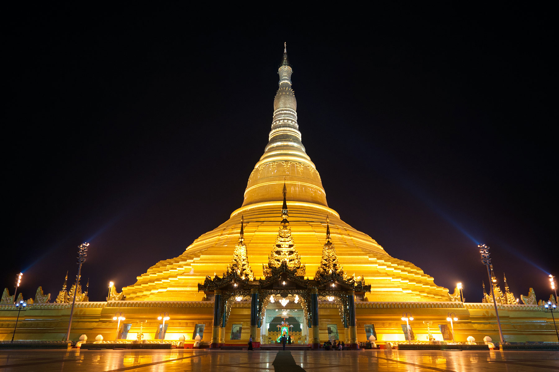
NAY PYI TAW
Naypyitaw was built in the central basin of Myanmar in the early 21st century to serve as the country’s new administrative center.
In 2004 construction of Naypyitaw began on an isolated site near the city of Pyinmana, some 200 miles (320 km) north of the then capital city of Yangon (formerly Rangoon).
Holding that relocation of the capital would facilitate accessibility of the government from all parts of the country, the administration began its move in 2005, first to Pyinmana and then to Naypyitaw, which was proclaimed the capital in March 2006.
In its early years Naypyitaw consisted of little more than government buildings, luxury hotels, apartments, and an airport, and it was populated primarily by civil servants, many of whose families remained in Yangon because of the lack of shops, restaurants, and other amenities in the new capital.
Despite its limited facilities, the burgeoning city was provided with an uninterrupted supply of electricity—a rarity elsewhere in the country.
Use of the airport at Naypyitaw generally has been restricted to military personnel; otherwise, the city is accessible by road or by rail (with a station at nearby Pyinmana) from Yangon.
MANDALAY
Mandalay, city, north-central Myanmar (Burma), the second largest in the country (after Yangon [Rangoon]).
Located on the Irrawaddy River, it lies at the centre of mainland Myanmar and is the focus of regional communications and trade and transportation routes.
Mandalay was built mainly in 1857–59 by King Mindon to replace Amarapura as his capital.
It was the last capital of the Myanmar kingdom and fell to British troops in November 1885.
During World War II the city was occupied by the Japanese and was almost completely destroyed, sustaining the heaviest damage during a 12-day siege in March 1945, when it was retaken by the British Fourteenth Army commanded by General Sir William Slim.
Buddhists are a majority in Mandalay, which is said to represent “the indestructible heart of Myanmar.” As an important Buddhist religious centre, it is the home of large numbers of monks (hpongyi).
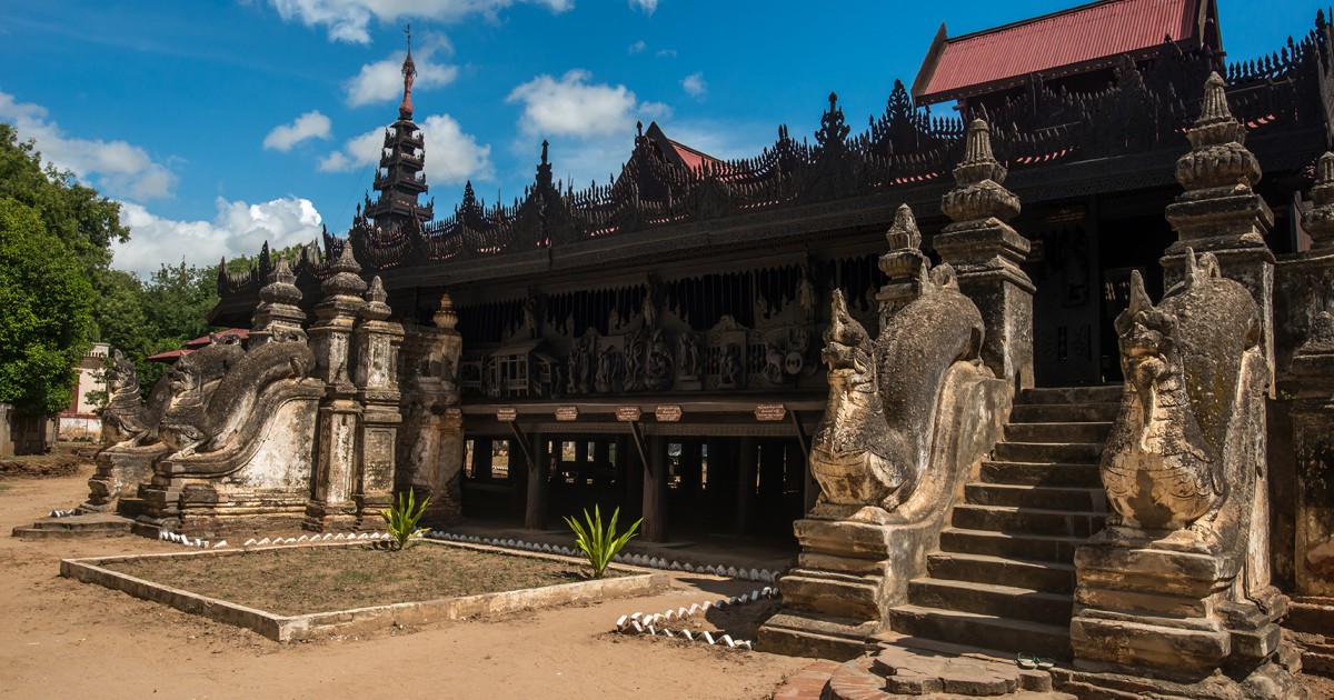
The core of the city includes the moated citadel of Fort Dufferin, the ruins of the royal palace (Nandaw), numerous temples and monasteries, and the old British Government House. Mandalay Hill, northeast of the cantonment near the river, is the location of relatively recent monasteries, pagodas, and monuments.
At its foot are the 730 pagodas, or Kuthodaw (“Works of Royal Merit”), authorized by King Mindon as a result of the Fifth Buddhist Council.
Buddhist scriptures, regarded by Myanmar Buddhists as orthodox texts, are recorded on 729 white marble tablets, and the tablets are set up in a square, each tablet protected by a small pagoda.
The 730th pagoda is a conventional temple occupying the centre of the square. The Mahamuni, or Arakan, pagoda, south of the city, is often considered Mandalay’s most famous. Its brass Buddha (12 feet [3.7 metres] high), believed to be of great antiquity, is one of numerous spoils of war brought from the Arakan Coast in 1784 by King Bodawpaya.
The city proper, west of the palace, is laid out in a gridiron pattern. Its famous Zegyo bazaar is the largest of many markets that attract artisans and farmers from throughout the country.
The Shwe Kyimyint pagoda, built by King Minshinsaw in 1167, is among the many fine pagodas in that part of the city.
Industries include tea packing, silk weaving, brewing and distilling, jade cutting, brass and copper casting, and gold-leaf work.
Matches, wood carvings, and goldware and silverware are also produced. Mandalay is linked by train and air south to Yangon and north to Myitkyinā and to Lashio, where the Burma Road begins. The nearby towns of Ava, Amarapura, and Sagaing are suburbs of Mandalay.
The Arts and Science University, formerly affiliated with Yangon University, attained independent status in 1958. Other educational facilities include a teacher-training college, agricultural, medical, and technical institutes, a technical high school, and a school of fine arts, music, and drama.
The city also has a museum and a hospital. The country’s only daily newspapers outside Yangon are published there.
The surrounding area is wooded (bamboo) and well watered by the Myitnge and Magyi (Madaya) rivers. The Saygin Hills near Madaya yield alabaster, which is carved into Buddha images in Mandalay.
The plains area is part of Myanmar’s dry zone. There is considerable irrigation; the Mandalay Canal irrigates 90,000 acres (36,400 hectares). Mingun, just north of Mandalay, has one of the world’s largest ringing bells, weighing about 70 tons.
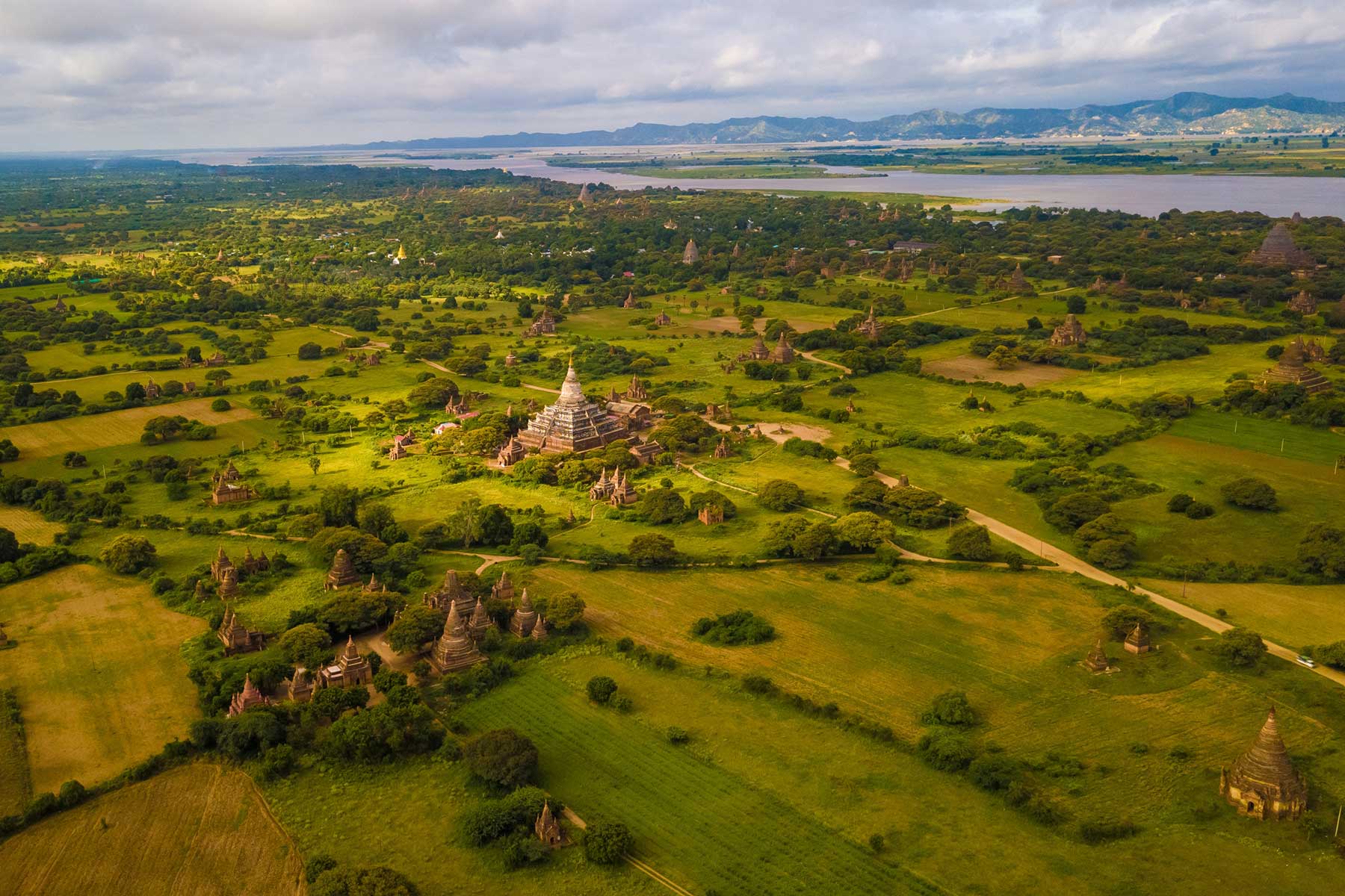
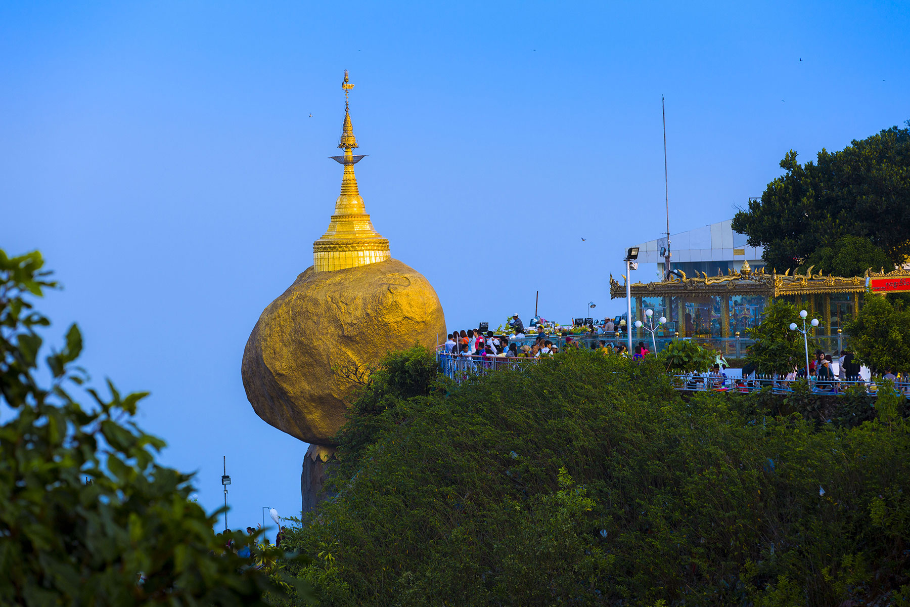
BAGAN
Bagan, village, central Myanmar (Burma), situated on the left bank of the Irrawaddy River and approximately 90 miles (145 km) southwest of Mandalay. The site of an old capital city of Myanmar, Bagan is a pilgrimage center and contains ancient Buddhist shrines that have been restored and redecorated and are in current use. Ruins of other shrines and pagodas cover a wide area. An earthquake on July 8, 1975, severely damaged more than half of the important structures and irreparably destroyed many of them. The whole of the Buphaya pagoda, for nine centuries a landmark for riverboatmen, tumbled into the Irrawaddy and was carried off by the waters. The village also has a school for lacquer ware, for which the region is noted.
Bagan’s importance lies in its heritage rather than its present. It was first built probably in 849 CE and, from the 11th century to the end of the 13th, was the capital of a region roughly the size of modern Myanmar. In 1287 it was overrun by the Mongols during their wide-ranging conquests, and it never recovered its position, though a little desultory building continued on Buddhist shrines.
Old Bagan was a walled city, its western flank resting on the Irrawaddy River. It was the focus of a network of highroads by means of which its rulers could command a large region of fertile plains and could dominate other major Myanmar dynastic cities, such as Pegu. From the port of Thiripyissaya, further down the river, important overseas trade was conducted with India, Ceylon, and other regions of Southeast Asia. The walls of the old city, within which lies a substantial area of the modern town, probably originally contained only royal, aristocratic, religious, and administrative buildings. The populace is thought to have lived outside in homes of light construction closely resembling those occupied by the present-day inhabitants. The walled city, whose moats were fed by the Irrawaddy, was thus a sacred dynastic fortress. The circuit of its walls and river frontage is some 2.5 miles (4 km), and there is evidence that perhaps as much as a third of the old city has been washed away by the river. Because building was principally in brick, decoration was carried out in carved brick, in stucco, and in terra-cotta. The earliest surviving structure is probably the 10th-century Nat Hlaung Gyaung. The shrines that stand by the Sarabha Gate in the eastern wall, although later than the wall they adjoin, are also early. These are shrines of protecting nats—the traditional spirit deities of the animist ethnic Burmans.
Between about 500 and 950, people of the Burman ethnic group had been infiltrating from the north into a region occupied by other peoples; these people already had been converted to Indian religion, especially the Mahayana Buddhism of Bihar and Bengal. Under King Anawrahta (reigned 1044–77), the ethnic Burmans finally conquered the other peoples of the region, including a people called the Mon, who were previously dominant in the south. They transported the Mon royal family and their scholars and craftsmen to Bagan, making it the capital and center of an official, fundamentalist form of Hinayana (Theravada) Buddhism adopted from Ceylon (Sri Lanka), about 1056. This initiated the period of Bagan’s greatness, which was sustained at first by Mon artistic traditions. The enormous number of monasteries and shrines built and maintained during the next 200 years was made possible both by the great wealth of the royal exchequer and by the large number of slaves, skilled and unskilled, whose working lives were dedicated to the support of each institution. The city became one of the most important centers of Buddhist learning.
Lesser buildings are grouped around the more important pagodas and temples. Scattered around these are smaller pagodas and buildings, some of which may once have been aristocratic palaces and pavilions later adapted to monastic uses—e.g., as libraries and preaching halls. All are based on Indian prototypes, modified during subsequent development by the Mon. The principal architectural theme is the Buddhist stupa, a tall bell dome, designed originally to contain near its apex the sacred relics of Buddhist saints. Another is the high, terraced plinth, which may be supplemented by stairs, gateways, extra stupas, and pinnacles and symbolizes a sacred mountain. During the course of artistic evolution, the themes were frequently combined, and the combination opened into a complex rectangular hall with porticos extended from the sides, crowned by a stupa or, in some cases, by a rectangular tower of curved outline reminiscent of the contemporary Indian Hindu shrine tower. Interior arches and vaults, both rounded and pointed, are, however, constructed by a true radiating-arch technique that was not used in India. A vista across the site of Bagan shows a series of variations and combinations of the themes. Many buildings, especially those no longer in use and hence unrestored, bear substantial remains of external, decorative stucco and terra-cotta (adding flamboyance to the finely proportioned rectilinear structures) and internal paintings and terra-cottas recording Buddhist legend and history.
Anawrahta constructed the Shwezigon pagoda. Nearby he built a nat shrine with images. The Shwezigon is a huge, terraced pyramid, square below, circular above, crowned by a bell-shaped stupa of traditional Mon shape and adorned with stairways, gates, and decorative spires. It is much revered and famous for its huge golden umbrella finial encrusted with jewels. It was considerably damaged in the earthquake of 1975. Also revered are the late 12th-century pyramidal Mahabodhi, built as a copy of the temple at the site of the Buddha’s enlightenment at Bodh Gaya, in India, and the Ananda Temple just beyond the east gate, founded in 1091 under King Kyanzittha. By the time the Thatpyinnyu Temple was built (1144), Mon influence was waning, and a Burman architecture had evolved. Its four stories, resembling a two-staged pyramid, and its orientation are new. Its interior rooms are spacious halls, rather than sparsely lit openings within a mountain mass, as in the earlier style. This building combined the functions of stupa, temple, and monastery. The Burman style was further developed in the great Sulamani Temple and culminated in the Gawdawpalin, dedicated to the ancestral spirits of the dynasty (late 12th century), whose exterior is decorated with miniature pagodas, the interior with extremely lavish, colored surface ornament.

MONYWA
Monywa, town, central Myanmar (Burma).
It is situated on the left bank of the Chindwin River, about 60 miles (97 km) west of Mandalay.
During World War II, the town was a Japanese communications centre and was captured by the British in 1945.
In October of 1952, the Triple Alliance Pact was signed near Monywa, demarcating zones throughout Myanmar in which various ethnic and political groups, including the Karen, Shan, Kachin, and communists, would have power.
Monywa is situated in the dry zone above the confluence of the Mu and Chindwin rivers; paddy rice, sesame, millet, peas, wheat, and cotton are cultivated in the surrounding area.
Monywa’s manufactures include textiles and wood and bamboo products.
Copper is mined near Monywa, and a copper refinery has operated in Salingyi since 1976.
A hospital was built in Monywa in 1972. Paved roads and a railway line run through the town.
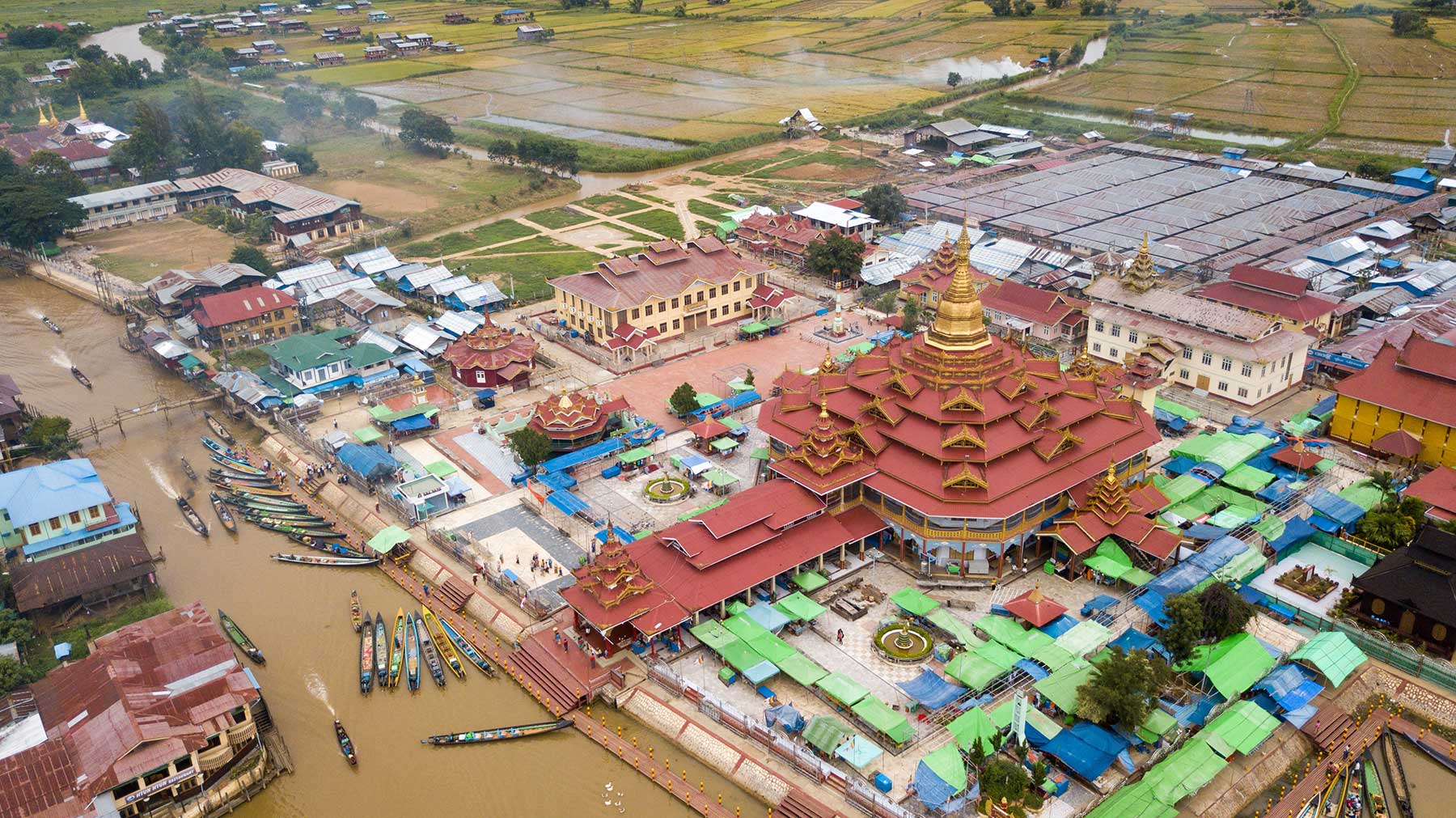
TAUNG GYI
Taunggyi, city, east-central Myanmar (Burma).
It lies on the Thazi-Keng Tung road at an elevation of 4,712 feet (1,436 metres), just north of Shwenyaung and Inle Lake.
Its facilities include hospitals, a technical high school, an institute for training teachers, the private Kan-Kambawza College (formerly a school for the sons of Shan chiefs), and Taunggyi College, affiliated with Mandalay’s Arts and Science University.
There is a hunting reserve nearby.

PAKOKKU
Pakokku, town, central Myanmar (Burma), on the Irrawaddy River below its junction with the Chindwin.
A trading centre for the Chindwin and Yaw river valleys, the town deals in timber and palm sugar and is the head of downstream Chindwin navigation.
It has an airfield and a diesel-electric plant. The model village of Kyauksauk is immediately northwest.
The area east of Pakokku is characteristic of Myanmar’s dry zone, with undulating gravelly and sandy land.
The Chindwin and Irrawaddy rivers provide alluvium and are utilized for irrigation.
To the west, over the Shinmataung and Tangyi ridges, the region is drained by the Yaw and Myittha rivers.
Peanuts (groundnuts), millet, and sesame are the principal crops. In the riverine areas sugar is produced from the toddy palm.
Rice, gram, peas, beans, tobacco, and corn (maize) are also grown, the latter primarily for its husk, which is used for cheroot wrappers under the name of yawpet.
The western forests yield teak. In the Yaw River valley, cutch, a yellow dye, is extracted from a type of small acacia tree.
The Yenangyat oil field is to the south of the town.
Nearby riverine towns include Gangaw and Tilin on the Myittha and Pauk and Seikpyu on the Yaw. The inhabitants are mainly Burman.
MAWLAMYINE
Mawlamyine, town, southeastern Myanmar (Burma). It is an important port on the Gulf of Martaban near the mouth of the Salween River.
Mawlamyine was the chief town of British Burma from the Treaty of Yandabo (1826) until the annexation of Pegu in 1852.
Sheltered by Bilugyun Island, it is approached from the south and lies opposite Martaban at the confluence of the Gyaing and Ataran rivers.
The low hills that flank the town on the east and west are dotted with ancient pagodas, including the Kyaikthanlan, renowned for its view, and Uzina, with life-sized figures representing the four events that influenced the Buddha to become a hermit.
The city lies in an area that has a sizable Mon population.
Mawlamyine has ferry service to Martaban, which is the railhead for a line to Yangon (Rangoon).
Another rail line begins at Mawlamyine and ends at Ye to the south. River steamers ply the lower Salween and several of its major tributaries.
Teak and rice are floated downriver for export, and there are several steam-powered rice mills and sawmills.
Mawlamyine was once a busy shipbuilding centre, and it has remained an important port.
It has an airport, a diesel electric plant, and a museum and is noted for its gastronomy.
Mawlamyine College is affiliated with the Arts and Science University of Yangon. A state teacher-training college and a large hospital are also located there.
Mawlamyine is the site of a solar-powered plant for extracting salt from seawater.
PYIN OO LWIN
Maymyo, also called Pyin Oo Lwin, town, central Myanmar (Burma).
It lies at the head of a shallow valley, at an elevation of about 3,450 feet (1,050 metres).
The town, named for Colonel (later Major General) James May of the 5th Bengal Infantry stationed there in 1886, served as the summer capital during the British administration.
The town is spaciously laid out in broad roads lined with eucalyptus, silver oak, and pine.
The flowers, fruits, and vegetables produced in its many large gardens are widely distributed.
There is a training centre for army officers.
Maymyo is reached by road from Mandalay and by rail and air from Yangon (Rangoon).
It has notable botanical gardens, and there is a hunting reserve nearby.
The town has a technical high school.
MAGWE
Magwe, Burmese Magway, town, west-central Myanmar (Burma). The town is on the Irrawaddy River opposite Minbu.
It is the site of Magwe College, affiliated to the Arts and Science University at Mandalay, and has an airfield.
The surrounding area is part of the dry zone of Myanmar’s central basin between the Irrawaddy to the west and the Pegu Mountains to the east.
Along the river, the land undulates, with marked development of river terraces.
It is seamed with nonperennial streams, only the Taungu (Yanbe) being perennial.
Situated in a zone of crustal instability, the area experiences occasional earthquakes.
Because the region is subject to monsoons and droughts, irrigation projects have been constructed to enable the growing of paddy rice and sesame, peanuts (groundnuts) for oil processing, and tobacco.
Millet is also grown. The Pegu Mountains hold valuable forest reserves.

MINBU
Minbu, town, west-central Myanmar (Burma), on the Irrawaddy River opposite Magwe (Magway) town.
The river there is about 3 miles (5 km) wide but contains many islands and sandbanks, and in the dry season steamers can come no nearer than 4 miles (6.5 km) south of the town.
Although much of the surrounding land is semidesert scrub forming part of Myanmar’s dry zone, large areas around Minbu are irrigated by the Mon, Maw, and Salin rivers.
The area is the site of one of the three historic irrigation systems in Myanmar and has modern irrigation works.
Sesame, millet, gram, peanuts (groundnuts), and other crops are grown in the nonirrigated lowland.
Fishing is an important economic activity.
There is oil in mud volcanoes, and small oilfields have been developed in the line of hills running through Minbu, which is the site of a diesel electric plant.

MYEIK
Mergui Archipelago, group of more than 200 islands in the Andaman Sea off the Tenasserim coast of extreme southeastern Myanmar (Burma).
The island cluster begins with Mali Kyun (Tavoy Island) in the north and ends beyond the southern limits of Myanmar.
The group includes Kadan (King), Thayawthadangyi (Elphinstone), Daung (Ross), Saganthit (Sellore), Bentinck, Letsok-aw (Domel), Kanmaw (Kisseraing), Lanbi (Sullivan’s), and Zadetkyi (St. Matthew’s) islands.
Mountainous and jungle-covered, the islands of the archipelago are known for their scenic beauty.
The islands’ chief inhabitants are the Selungs, or Salons.
Tin and tungsten (wolfram) are mined on some islands, and there is an old, established pearl-fishing industry.
Other products include edible birds’ nests and sea cucumbers.